Underground utility mapping is an essential process that helps prevent accidents and damages during construction projects. It involves identifying the location, type, and depth of various underground utilities like water pipes, gas lines, power cables, and communication networks.
However, mapping underground utilities poses several challenges that can delay or halt a project if not addressed correctly. One of the primary challenges of underground utility mapping is the lack of accurate information about existing infrastructure. Most utility maps are outdated or incomplete, making it difficult to determine the exact location and depth of underground utilities.
Furthermore, some utilities may have been installed without proper documentation, making their identification even more challenging. Other factors such as soil composition and weather conditions can also affect the accuracy of mapping efforts.
In this article, we will discuss some strategies for success in overcoming these challenges and ensuring successful underground utility mapping.
Importance Of Accurate Underground Utility Mapping
Accurate underground utility mapping is crucial for the success of any construction project. Without precise information on the location and depth of utilities, construction workers risk damaging or disrupting vital infrastructure, leading to costly repairs and delays. Inaccurate mapping can also pose safety hazards for workers and the general public.
In addition to preventing damage and delays, accurate utility mapping can also save time and money by reducing the need for exploratory digging or excavation. When contractors have confidence in their knowledge of where utilities are located, they can plan more efficiently and avoid costly mistakes. Accurate mapping can also help with long-term maintenance planning, as utility owners can identify areas that may require upgrades or repairs.
Despite its importance, accurate underground utility mapping is often a challenging task. Many utilities were installed decades ago without proper documentation, making it difficult to determine their exact locations. Additionally, new utilities are frequently added without updating existing maps.
However, with the right strategies and technologies in place, accurate mapping is achievable.
Outdated And Incomplete Utility Maps
Outdated and incomplete utility maps are one of the most significant challenges in underground utility mapping. These maps can lead to costly mistakes, delays, and even accidents during excavation or construction. Unfortunately, many utilities have been installed without proper documentation or record-keeping, making it challenging to produce accurate maps.

One reason for outdated maps is the lack of standardization and coordination among utility companies and local authorities. Each company has its own way of recording and storing data, which often results in inconsistencies and gaps in information. Additionally, changes made over time are not always recorded accurately, leading to discrepancies between the actual location of utilities and their representation on maps.
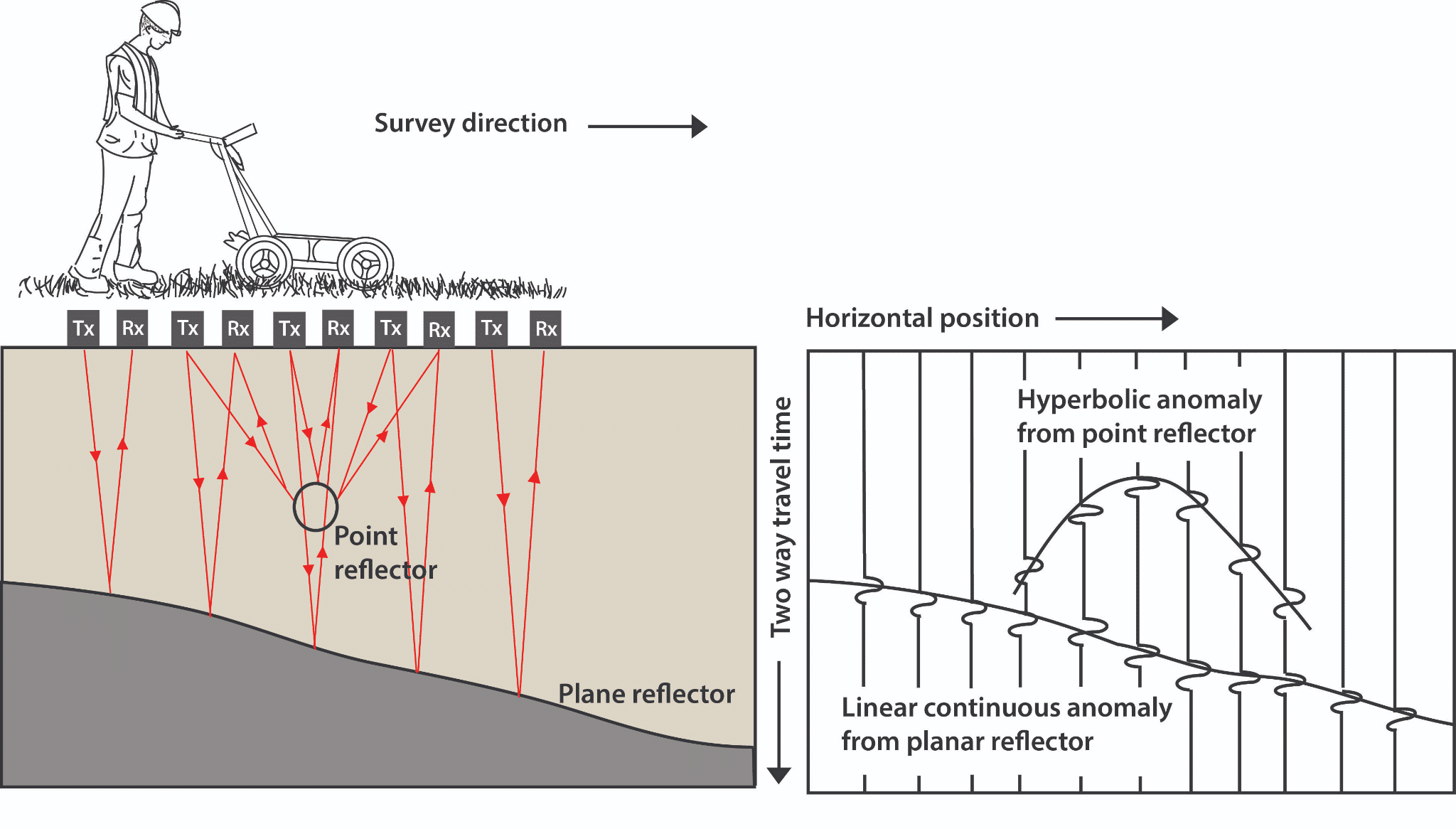
Another issue is the reliance on outdated technologies and techniques for mapping underground utilities. Traditional methods such as ground-penetrating radar (GPR) or electromagnetic induction (EMI) have limitations that prevent them from providing a complete picture of subsurface infrastructure. As a result, these methods may miss critical information such as abandoned pipes or undocumented cables, leading to inaccuracies in the map.
Addressing these challenges requires a concerted effort from all stakeholders involved in utility mapping. Standardization of data collection and storage practices is essential for producing accurate maps that can be accessed by all relevant parties.
Moreover, adopting new technologies such as LiDAR scanning or drone-based surveys can provide more comprehensive data about subsurface infrastructure. By embracing these strategies, we can overcome the challenges presented by outdated and incomplete utility maps and ensure safe and efficient construction practices for years to come.
Identifying Utilities Installed Without Documentation
Identifying Utilities Installed Without Documentation can be a daunting task for underground utility mapping. It is not uncommon to come across utilities that have been installed without any documentation or records. These undocumented utilities pose a significant challenge, as they are not known to the utility owners and may contain hazardous materials.
To identify these utilities, it is essential to employ various methods such as geophysical surveys and visual inspections. Geophysical surveys involve the use of electromagnetic waves to locate and map underground utilities. This method is non-intrusive and can detect both metallic and non-metallic utilities.
Visual inspections, on the other hand, require excavation works where technicians carry out a physical inspection of the area to identify any undocumented utilities.
Here are some strategies that can be employed when identifying undocumented utilities:
– Conducting historical research: Researching through historical records can help identify any past utility installations in an area.
– Engaging local communities: Engaging with local communities can provide insight into any underground installations that may have occurred without documentation.
– Employing advanced technology: Advanced technologies such as ground-penetrating radar (GPR) and LiDAR scanning can provide highly accurate results when locating underground
Utilities.
By employing these strategies, identifying undocumented utilities becomes an easier task in underground utility mapping. However, it is important to note that documenting all identified utilities is crucial for future reference purposes.
Effects Of Soil Composition And Weather Conditions
Soil composition and weather conditions play a crucial role in underground utility mapping.
Soil composition affects the accuracy of locating underground utilities, as it can interfere with the signals sent by utility locators. For instance, clay soils are dense and highly conductive, which makes it difficult for electromagnetic waves to penetrate through them. Therefore, utility locators may not be able to detect utilities accurately in such soil types.
Similarly, weather conditions can also affect underground utility mapping accuracy. For example, heavy rainfall can disrupt the signal transmission between utility locators and the buried utilities. The water in the soil acts as a conductor, which absorbs much of the electromagnetic energy transmitted by the locator’s antenna. This results in reduced detection range and lower accuracy.
Moreover, extreme temperatures can also affect underground utility mapping accuracy. In cold weather conditions, frozen ground can make it challenging to dig up or locate utilities precisely. On the other hand, high temperatures can cause soil expansion that may shift or damage buried utilities.
Hence, it is crucial to consider weather conditions when planning an underground utility mapping project to ensure accurate and reliable results.
In conclusion, soil composition and weather conditions are critical factors that affect underground utility mapping accuracy. Utility mapping professionals must consider these factors while planning and executing their projects to avoid errors or delays in detecting buried utilities accurately. By taking these factors into account, professionals could increase their chances of success in completing projects efficiently while minimizing risks associated with inaccurate locating of utilities.
Strategies To Overcome Mapping Challenges
Accurate mapping of underground utilities is a complex process that involves the use of advanced technologies and equipment. The challenges faced during this process can be numerous, ranging from environmental factors to technical difficulties. However, with careful planning and implementation of strategies, these challenges can be overcome.
In this section, we will discuss some effective strategies that can help in achieving successful mapping of underground utilities. One of the most important strategies for overcoming mapping challenges is to conduct a thorough site survey before initiating the mapping process. This involves gathering relevant information about the site such as soil conditions, surface features, and existing utility infrastructure. By doing so, it becomes easier to identify potential obstacles that may hinder the mapping process and take necessary measures to address them.
Another effective strategy is to use multiple technologies for mapping underground utilities. For instance, while ground penetrating radar (GPR) is commonly used for detecting pipes and cables buried beneath the surface, it may not always provide accurate results due to varying soil conditions. Therefore, combining GPR with other technologies such as electromagnetic detectors or acoustic sensors can help in obtaining more precise data.
In conclusion, successful mapping of underground utilities requires careful planning and implementation of various strategies. Conducting a thorough site survey beforehand, using multiple technologies for detection, and collaborating with experienced professionals are just some of the ways in which mapping challenges can be overcome. By adopting these strategies and staying up-to-date with advancements in technology and techniques, accurate mapping of underground utilities can become a reality.
Ensuring Successful Underground Utility Mapping
Having discussed the various challenges that come with mapping underground utilities, it is important to focus on strategies that can be employed to overcome these difficulties. Several approaches exist, including the use of advanced technologies such as GPR and EM, as well as proper planning and preparation before undertaking any project.
One effective strategy is the creation of a detailed map of all existing utility infrastructure within the area. This would involve locating and identifying all underground utilities, including water mains, gas pipes, electrical lines, and fiber optic cables. The map should also include details regarding their depth and location relative to other structures such as buildings and roads.
Another approach is the use of specialized equipment designed for underground detection. Ground penetrating radar (GPR) can accurately detect the location of buried objects by transmitting high-frequency radio waves into the ground and measuring the reflections caused by different materials beneath the surface. Electromagnetic (EM) detectors are also useful in identifying metallic objects such as pipes and cables by detecting changes in magnetic fields.
In order to ensure successful underground utility mapping, it is crucial to engage experienced professionals who possess knowledge and expertise in this field. These experts can provide valuable insights regarding best practices, safety guidelines, and appropriate equipment needed for specific projects.
By following these strategies, stakeholders can effectively manage risks associated with underground utility mapping while minimizing disruptions caused by unexpected interruptions or delays.
Conclusion
In conclusion, accurate underground utility mapping is crucial for preventing damage to existing infrastructure and ensuring the safety of construction workers.
However, outdated and incomplete utility maps, identifying undocumented utilities, and weather conditions can pose challenges in achieving accurate mapping.
To overcome these challenges, it is essential to use advanced technology such as ground-penetrating radar and electromagnetic locators.
It is also important to conduct onsite inspections, collaborate with utility companies and other stakeholders, and maintain accurate records of all mapping activities.
By implementing these strategies and taking a proactive approach to underground utility mapping, we can ensure successful outcomes for construction projects while protecting our communities’ infrastructure.